Sand Volcano on:
[Wikipedia]
[Google]
[Amazon]


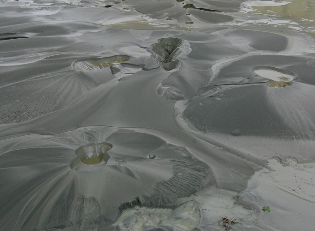
 Sand boils or sand volcanoes occur when water under pressure wells up through a bed of sand. The water looks like it is boiling up from the bed of sand, hence the name.


 Sand boils or sand volcanoes occur when water under pressure wells up through a bed of sand. The water looks like it is boiling up from the bed of sand, hence the name.
Sand volcano
A sand volcano or sand blow is a cone ofsand
Sand is a granular material composed of finely divided mineral particles. Sand has various compositions but is defined by its grain size. Sand grains are smaller than gravel and coarser than silt. Sand can also refer to a textural class of s ...
formed by the ejection of sand onto a surface from a central point. The sand builds up as a cone
A cone is a three-dimensional geometric shape that tapers smoothly from a flat base (frequently, though not necessarily, circular) to a point called the apex or vertex.
A cone is formed by a set of line segments, half-lines, or lines con ...
with slopes at the sand's angle of repose. A crater is commonly seen at the summit. The cone looks like a small volcanic cone
Volcanic cones are among the simplest volcanic landforms. They are built by ejecta from a volcanic vent, piling up around the vent in the shape of a cone with a central crater. Volcanic cones are of different types, depending upon the nature and ...
and can range in size from millimetres to metres in diameter.
The process is often associated with soil liquefaction and the ejection of fluidized sand that can occur in water-saturated sediments during an earthquake
An earthquake (also known as a quake, tremor or temblor) is the shaking of the surface of the Earth resulting from a sudden release of energy in the Earth's lithosphere that creates seismic waves. Earthquakes can range in intensity, fr ...
. The New Madrid Seismic Zone
The New Madrid Seismic Zone (), sometimes called the New Madrid Fault Line, is a major seismic zone and a prolific source of intraplate earthquakes (earthquakes within a tectonic plate) in the Southern and Midwestern United States, stretching t ...
exhibited many such features during the 1811–12 New Madrid earthquakes. Adjacent sand blows aligned in a row along a linear fracture within fine-grained surface sediments are just as common, and can still be seen in the New Madrid area.
In the past few years, much effort has gone into the mapping of liquefaction features to study ancient earthquakes. The basic idea is to map zones that are susceptible to the process and then go in for a closer look. The presence or absence of soil liquefaction features is strong evidence of past earthquake activity, or lack thereof.
These are to be contrasted with ''mud volcano
A mud volcano or mud dome is a landform created by the eruption of mud or slurries, water and gases. Several geological processes may cause the formation of mud volcanoes. Mud volcanoes are not true igneous volcanoes as they do not produce la ...
es'', which occur in areas of geyser or subsurface gas venting.
Flood protection structures
Sand boils can be a mechanism contributing to liquefaction and levee failure during floods. This effect is caused by a difference in pressure on two sides of alevee
A levee (), dike (American English), dyke (English in the Commonwealth of Nations, Commonwealth English), embankment, floodbank, or stop bank is a structure that is usually soil, earthen and that often runs parallel (geometry), parallel to ...
or dike
Dyke (UK) or dike (US) may refer to:
General uses
* Dyke (slang), a slang word meaning "lesbian"
* Dike (geology), a subvertical sheet-like intrusion of magma or sediment
* Dike (mythology), ''Dikē'', the Greek goddess of moral justice
* Dikes ...
, most likely during a flood. This process can result in internal erosion
Internal erosion is the formation of voids within a soil caused by the removal of material by seepage. It is the second most common cause of failure in levees and one of the leading causes of failures in earth dams, responsible for about half of ...
, whereby the removal of soil particles results in a pipe through the embankment. The creation of the pipe will quickly pick up pace and will eventually result in failure of the embankment.
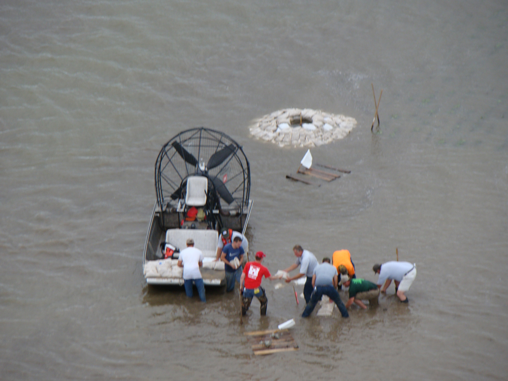
A sand boil is difficult to stop. The most effective method is by creating a body of water above the boil to create enough pressure to slow the flow of water. A slower flow will not be able to move soil particles. The body of water is often created with sandbag
A sandbag or dirtbag is a bag or sack made of hessian (burlap), polypropylene or other sturdy materials that is filled with sand or soil and used for such purposes as flood control, military fortification in trenches and bunkers, shielding gl ...
s forming a ring around the boil.
During the flood of spring 2011, the United States Army Corps of Engineers
, colors =
, anniversaries = 16 June (Organization Day)
, battles =
, battles_label = Wars
, website =
, commander1 = ...
had to work to contain the largest sand boil ever discovered. The sand boil measured 30 feet by 40 feet and was located in the city of Cairo, Illinois at the confluence of the Mississippi River
The Mississippi River is the second-longest river and chief river of the second-largest drainage system in North America, second only to the Hudson Bay drainage system. From its traditional source of Lake Itasca in northern Minnesota, it f ...
and the Ohio River
The Ohio River is a long river in the United States. It is located at the boundary of the Midwestern and Southern United States, flowing southwesterly from western Pennsylvania to its mouth on the Mississippi River at the southern tip of Illino ...
.
Earthquakes
An example of this is during the 1989 earthquake inSan Francisco
San Francisco (; Spanish language, Spanish for "Francis of Assisi, Saint Francis"), officially the City and County of San Francisco, is the commercial, financial, and cultural center of Northern California. The city proper is the List of Ca ...
, when sand boils brought up debris from the 1906 earthquake. This process is a result of liquefaction. By mapping the location of sand boils that erupted in the Marina District during the 1989 Loma Prieta earthquake, scientists discovered the site of a lagoon that existed in 1906. The lagoon developed after the Fair's Seawall was constructed, and was later filled in in 1915 in preparation for the Panama–Pacific International Exposition
The Panama–Pacific International Exposition was a world's fair held in San Francisco, California, United States, from February 20 to December 4, 1915. Its stated purpose was to celebrate the completion of the Panama Canal, but it was widely s ...
.
See also
*Internal erosion
Internal erosion is the formation of voids within a soil caused by the removal of material by seepage. It is the second most common cause of failure in levees and one of the leading causes of failures in earth dams, responsible for about half of ...
*Seepage
Soil mechanics is a branch of soil physics and applied mechanics that describes the behavior of soils. It differs from fluid mechanics and solid mechanics in the sense that soils consist of a heterogeneous mixture of fluids (usually air and wat ...
References
{{Reflist Sand Sedimentology Seismology